Meridian
Advertisement
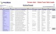
VisitorTrack (Lead Generation Technology) v.5 2
Powerful technology for lead generation drives, and converts invisible web visitors into real B2B leads. VisitorTrack turns transparent internet searches on Google and Yahoo into actionable sales leads. Get insight into who is looking,
Advertisement
GMT/UTC Time Check v.1.0
Yet another desktop clock. Time Check is an example of a software re-using the client resources, i.e. network, to retrieve the time from the NIST time server and redisplaying it in a different format. Doesn't do much,
Maxclock v.3.2
MAXCLOCK is a high-precision digital astronomical clock. An astronomical clock that can display civil date, julian date and mean solar time. It displays the following data on your computer screen: 1. Civil date & time, day number in the year; 2.

Denver Guide v.4.0.0.0
Denver (/ˈdɛnvər/) is the capital and the most populous city of the U.S. state of Colorado, with a population of 600,158 according to the 2010 census. Denver is a consolidated city-county,

AcuPoint v.1.6.0.0
AcuPoint is a reference tool for locating Acupuncture Points on the body. It contains anatomical descriptions as well as images depicting the points. This is a great tool for Oriental Medicine Practitioners and is powered by OrientalDiagnosis.
TCM PRO Ryodoraku v.1.0
The software TCM PRO - uses traditional acupuncture points for Ryodoraku measurement.
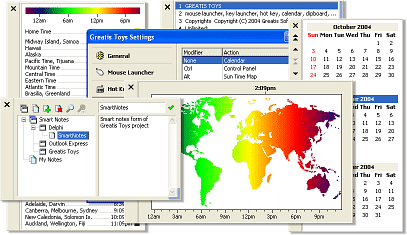
Greatis Toys v.2.1
Greatis Toys is a nice tray-based utility pack for Windows, contained several sections in one small and convenient program: Calendar This section can show the convenient three-month scrollable calendar, that automatically adapts to the local date set
TOPOWIN English v.13.00
TOPOWIN is a state-wide register of the German topographic cartographies and of localities with geo references in different coordinate systems. It also is a topographic information system.
Sizimg v.1.24
Images can be resized with the use of the command-line tool sizimg.
XEphem v.3.6
A scientific-grade interactive astronomical ephemeris package.
Geodata International v.10.05
Geodata International - World-wide database of countries with georeferenced towns, municipalities, postal codes and administrative units with WGS84 and UTM coordinates and elevations for geocoding, proximity search, navigation, distance calculation.